Werewolves, devils, dragons, house spirits, giants, elves - ethnographic sources allow to identify the places associated with these beings. Scientists and artists have created a map of Pomerania and Mecklenburg illustrated with linocuts inspired by Renaissance cartography, presenting 19th-century folk imaginations.
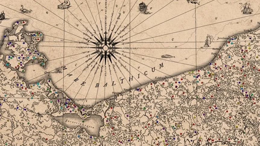
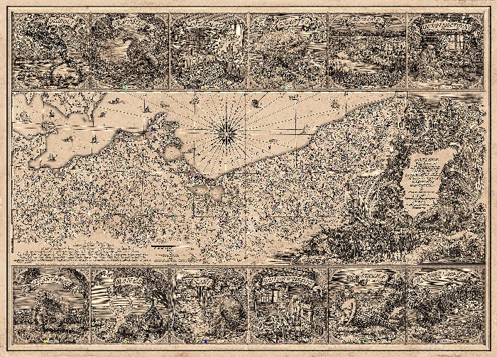
Researchers have prepared a stylised 1:720,000 map as part of a research project funded by the Polish National Science Centre. They have now made it available online for free as part of a scientific publication in the Journal of Maps (https://www.tandfonline.com/doi/full/10.1080/17445647.2024.2434015).
Residents of Pomerania, enthusiasts of folklore and fantasy, maps and infographics, art lovers, as well as ethnographers and cartographers can download the map and check which places in Pomerania were associated with the occurrence of ghosts, ghouls, werewolves or water spirits 150 years ago.
The unique map of demonic characters was developed by an interdisciplinary team, including an ethnographer, cartographer, historian of cartography, graphic artist, writer, computer scientist.
ETHNOLOGIST: ANALYSES FOLCLORISTIC SOURCES
Robert Piotrowski, PhD, an ethnologist from the Interdisciplinary Anthropocene Research Team of the Institute of Geography and Spatial Organization of the Polish Academy of Sciences analysed materials by German and Polish folklorists (including Otto Knoop, Karol Bartsch, Oskar Kolberg, Stefan Ramułt), who wrote down the stories of the inhabitants of Pomerania at the turn of the 20th century. The researcher collected a total of 1,200 examples of beliefs and ideas about the supernatural world. The map was prepared based on 600 locations, in which local communities associated specific landscape elements, such as erratic boulders, moraine hills, or peat bogs, with supernatural legends.
'We were mainly interested in local tales of supernatural events associated with a specific place. For example, religious legends according to which witches met on a particular mountain, a certain boulder was once thrown by a giant, the devil built a dam on the lake, or will-o'-the-wisp appeared in a certain swamp. The combination of the natural and supernatural contexts allowed us to recreate the way in which the landscape was viewed by the inhabitants of the studied regions', Piotrowski explains.
He adds that at the beginning of the 20th century, beliefs related to the supernatural world helped explain natural phenomena and the origins of geological objects through the prism of ideas functioning in a given culture. Recognizing and defining them allowed to create a coherent image of reality - terrifying on the one hand, but on the other giving a sense of security, resulting from the orderliness of the world.
CARTOGRAPHER: PREPARES A MAP
Włodzimierz Juśkiewicz, PhD, a cartographer from the Institute of Geography and Spatial Organization of the Polish Academy of Sciences, emphasises that 'a map is a great tool to help understand the world around us'. The researcher wanted to prepare a fully cartometric map in line with contemporary knowledge. However, he decided that such interesting data deserved a form that went beyond the currently accepted cartographic standards. His goal was to attract the attention of recipients through an unusual form that would show the fascinating nature of the information presented.
Juśkiewicz concluded that the aesthetics of Renaissance maps would best reflect the atmosphere of the period, and best refer to the presented demonic figures. During the Italian Renaissance, maps were treated as works of art, and many of them were considered refined forms of art. Inspired by this tradition, he decided to combine scientific precision with artistic expression and create a map that would not only inform but also delight visually.
HISTORIAN OF CARTOGRAPHY: FINDS MONSTER MAPS
It was also significant that Renaissance maps were famous for their depictions of monsters. 'In the past, these monsters were used to fill blank spaces - for example, water or places on maps that were not yet fully known', explains Dariusz Brykała, PhD, from the Institute of Geography and Spatial Organization of the Polish Academy of Sciences, a geographer specialising in the history of cartography.
He adds that monsters also appeared in scientific publications as late as the 18th century, for example in the first version of Carl Linnaeus's taxonomy of the animal kingdom.
SCIENCE FICTION WRITER: COLLECTS GRAPHIC ELEMENTS FROM OLD MAPS
The aesthetics of Renaissance maps include details - graphic elements such as cartouches, borders or compass roses, as well as small signatures of trees, hills, animals, boulders, ships, which fill the space of the map and show landmarks.
In this case, the team used the experience of the American writer K.M. Alexander, who had been collecting such symbols and graphic elements extracted from old maps for years to create illustrations for his fantasy novels. He made his collection available to the Polish team and enriched it with sea beasts and monsters. This allowed to fill the map with hundreds of pictograms.
A computer scientist and Gdańsk University of Technology student helped to automate the placement of these small elements on the map so that they matched the range of contemporary geographic objects. He also supported the process of generalizing contemporary cartographic materials in the Geographic Information System.
GRAPHIC ARTIST: PREPARES LINOCUTS
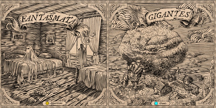
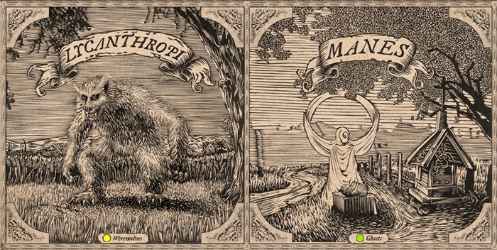
However, the map was still missing... a legend. It was necessary to develop original versions of illustrations depicting fantastic creatures. The artist - specializing in relief printing techniques, Jakub Jaszewski, PhD, from Nicolaus Copernicus University - used AI tools to design the style and appearance of individual demons. The AI sketches then became the starting point for further work. Matrices for 12 linocuts were prepared. The prints were made using the traditional method, and their digital copies were inserted onto the map.
And so the map's legend includes: the devil, the dragon, the ghost, the giant, the will-o'-the-wisps, the bane, the werewolf, the spirit, the elf, the house spirit, the mermaid and the wild hunt.
Jaszewski explains that woodcut (the matrix is wooden) and its modern equivalent, linocut (the matrix is made of linoleum) are relief printing techniques (this is how stamps work). 'Relief printing techniques were rarely used to create maps, because woodcut matrices could get damaged over time during printing. Cartography relatively quickly began to use intaglio printing techniques (etching, and later copperplate), i.e. techniques that allow to select a line in a metal matrix and colour it', he comments. However, linocut fits well into the convention of folk tales.
And so a map based on 19th-century ethnographic data was created. It is made in the Renaissance style, prepared using modern cartographic and artistic methods.
'Maps should focus on the recipient. The recipients should feel comfortable with the topic they are learning about. They must look through the map with bated breath. And we are creating a new trend in work on maps. We have taken a step forward, showing how to make modern maps. Now we are at the forefront, others will chase us, criticize us, copy us. But we are the ones showing a new form of presenting scientific content', Brykała says.
The team members believe that the map would not have been created if each of them had worked separately. They emphasise that this work was created thanks to conversations and passion of an interdisciplinary team.
When asked if they have plans to prepare similar maps for other parts of Poland, the researchers say that they will be happy to do that if they find a publisher. More projects are waiting in their drawers. (PAP)
Ludwika Tomala
lt/ zan/ amac/

