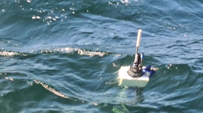
Meter-long, cylindrical, with a protruding antenna, underwater oceanographic Argo robots collect data about the Baltic Sea. They have been accidentally caught, causing concern because their shape resembles a torpedo. That is why the Institute of Oceanology of the Polish Academy of Sciences places clear markings on them, says oceanographer Daniel Rak, PhD.
Autonomous Argo floats provide previously unavailable information, helping scientists track climate change, detect dead zones and analyse all processes occurring under the water surface.
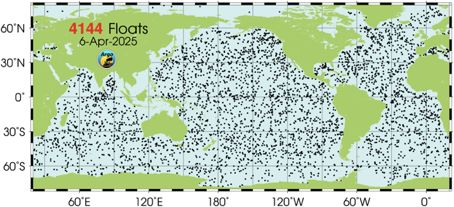
The global Argo system was created at the beginning of the 21st century to support scientists in conducting uninterrupted, global monitoring of the oceans, without the need to organize expensive research expeditions. It currently includes over 4 thousand autonomous floats that drift with sea currents and measure key physical parameters of water, primarily its salinity, temperature and pressure.
'Although they were created primarily to study oceans, not shallow seas, a dozen or so years ago Poland joined the Argo network and the floats also began to appear in the Baltic Sea', says Daniel Rak, PhD, from the Institute of Oceanology of the Polish Academy of Sciences in Sopot, who works on the Argo project.
He adds that this involved certain challenges, because the robots were not adapted to operate in waters with large, vertical salinity gradients, such as those in the Baltic Sea. However, over time they were adapted to such conditions as well.
The Argo floats operate without interruption, they monitor the sea all year round, regardless of the weather or season. They do not have propulsion systems, they drift with sea currents, controlling only their immersion. They can change their buoyancy thanks to a special pump and an oil bladder, which works like a fish swim bladder.
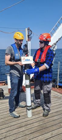
The Polish robots are launched from the deck of the research vessel Oceania. After the launch, they descend to the 'parking' depth determined by scientists, and emerge from time to time to send data via satellite to scientific centres.
There are eight active floats in the Baltic Sea region. The simplest ones measure water temperature, salinity and pressure. However, there are more complicated models, equipped with a number of additional sensors, capable of measuring pH, nitrate concentration or oxygen dissolved in water. They help, among other things, detect so-called dead zones, i.e. areas devoid of oxygen, in which marine animals cannot live.
'This is a very important function, because recently there have been more and more dead zones in the Baltic Sea. They used to occur mainly in the Gotland Deep, but recent studies show that they are starting to appear even in the Gdansk Deep. In such areas, due to the lack of oxygen, anaerobic bacteria decompose organic matter, which results in the formation of toxic hydrogen sulphide. This makes life for aquatic organisms practically impossible', Rak explains.
Data from the floats also allow to track global climate change and local processes related to a given body of water. The floats are used to monitor ecological conditions and analyse many processes, including water exchange and changes in water layering.
'In January 2024, one of the Polish floats operating in the Bornholm Basin region recorded a sudden increase in salinity and oxygen content at the bottom. This was a clear sign of the inflow of salty waters from the North Sea, which was almost immediately confirmed by foreign institutions monitoring the Baltic Sea', the researcher emphasises.
The floats can also be used in numerical models forecasting the weather and sea situation. Indirectly, they help determine the direction and speed of sea currents (based on the position of the device), and they support the calibration of sonars and echo sounders, important for both the military and fisheries.
Rak explains that the propagation of sound in water depends on its physical properties. Submarine sonars or fishing boat echo sounders assume a certain average speed of sound in water, which in reality can vary greatly. For example, an increase in temperature by 1 degree Celsius increases the speed of sound by about 4.5 m/s, and an increase in salinity by 1 PSU (practical salinity unit) - by about 1.3 m/s. These are seemingly small values, but in the case of large gradients between warm and less salty surface water and colder and more salty water at the bottom, a clear difference in the speed of sound can occur. In such a situation, sound is bent (refracted) at the boundary of layers, which for sonars means 'acoustic shadows' - areas in which they may not detect underwater objects correctly.
'For the devices to work effectively, it is therefore necessary to know the current profile of the speed of sound in the water and take it into account during calibration. This is where data from Argo floats come in handy. This is particularly important in the Baltic Sea, where hydrodynamic conditions can vary significantly even over a small area', Rak adds.
He explains that modern floats are relatively inexpensive but very effective. In the oceans, their operating time depends on battery life. In such vast waters, recovering devices once they have been released is usually not cost-effective. However, in the Baltic Sea, it is possible. Scientists from the Institute of Oceanology PAS often locate floats with discharged batteries, fish them out, service them and reuse them.
'We cannot obtain such temporal and spatial resolution with any other research platform. Research cruises enable observations only at a given time and in a given area. They only show a fragment of the entire hydrodynamic situation. Floats provide us with information constantly, without interruption, over large areas', the scientist from the Institute of Oceanology PAS concludes.
He emphasises that due to its size and shape, the Argo device could be mistaken for... a torpedo. They were sometimes accidentally fished out by fishermen or tourists, causing concern. That is why the Institute places clear markings on them. 'So if, while walking by the sea or on a cruise, you notice something resembling a torpedo in the water, do not panic. It is best to examine the device and contact the Institute of Oceanology of the Polish Academy of Sciences in Sopot', he emphasises.
PAP - Science in Poland, Katarzyna Czechowicz (PAP)
kap/ bar/ amac/